Sunday 26 September 2010

Brora - Dunnet Head - John O’Groats

Miles today 86.9
In 6hrs 06 mins burning 2581 Kcal climbing 4140ft

Miles total 1353
In 91hrs 54mins burning 41841 Kcal climbing 60713ft
Most miles in a day : 106.2

Miles For Year 5917
In 371 hrs burning 199395 Kcal Climbing 233123ft

Sorry for the delay in this last post which was due to lack of internet access. This blog relates to last Sunday.


Last day today. It was a dull, cool start as I came out onto the A9 and headed North East. Just a few yards up the road I get flashed and beeped at by an oncoming car. They wave, they know where I am heading and what I am doing. It is touching.


Twenty six years ago I had ridden Land’s End - John O’Groats, and had gone straight up the A9, so this time would be different and I would take the A897 from Helmsdale to Melvich. So just over 3 miles in I turned left up a single track road to cut the corner off and started a 7 mile 1200ft climb up Glen Loth. It felt immensely remote.

Joining the A897, I turned north and with a south easterly tailwind made good time on a long slow ascent beside the railway line. It was single track with passing places all the way, and there were maybe 8 cars on the whole road. I slowly climbed out of the farmed and lightly treed area, up onto the heather moor. It stretches as far as you can see. Over the watershed and running on back towards the north coast. The railway turns east to divide for both Wick and Thurso.


This is an A Road


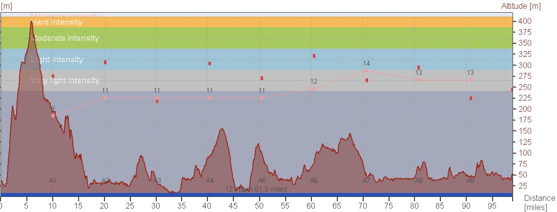
I can see the sea! There is nothing north of here for thousands of miles. Turn east. Then commences a 44 mile ride into a cross headwind that grew in intensity. I knew as I rode it that it was up and down, but the profile shows how much so. I was tired and hungry. Denise kept feeding me every 10miles or so. I can see the Orkney, and finally Dunnet Head comes into view. It is rather high, and I am going to have to go up there.


Dunnet Head
Through Thurso, and 1300miles into the ride, and I get the one last idiot, and indeed only one, who decides to blast his horn beside me, and swerve the car from side to side as he passes. I salute him in the customary way.

Finally a rest from the wind as I turn north onto Dunnet Head. This single track road is remarkably busy, as people drive up to the lighthouse. I arrive, Denise runs over and hugs me with a big bee. People look bemused, much as I feel. I am not there yet.


Dunnet Head

Pictures and hugs over and it is back down the hill, dodging the tourists, and back onto the main road. I continue into the wind. 14mph is my friend it seems. I notice the sat nav says 7 miles to go, and it occurs it is the last 7 miles. It seems that this ride is not going to give itself up to me easily, the wind increases, the sky spits water at me, I grind on. I am not stopping. They will have to take me away in an ambulance for me not to finish. I'll carry the bike from here if it breaks down.


Duncansby Head Lighthouse


John O’Groats, but this is not the real finish. A lot of official finishes are in the car park, by the visitor centre, but the furthest point is the lighthouse at Duncansby Head, another 2 miles on and up another hill.


I arrive to bee laden hugs. No big fanfare, just the knowledge that I did it, I did it all, 16 consecutive, windy, wet, cool days, no walking, no tucking in behind others, no one to talk to when it got hard on the road. Just me, my bike and a bee.


Tuesday 21 September 2010

Fort Augustas - Brora

Miles today 98.9
In 6hrs 36 mins burning 2795 Kcal climbing 4280ft

Miles total 1266
In 85hrs 48mins burning 39260 Kcal climbing 56573ft
Most miles in a day : 106.2

The View
Another day, another spot of rain. 4 hours of it this time, and colder.

Fort Augustus is at the south west end of Loch Ness, and there are roads up the south and north side of the Loch, both ending up in Inverness. There is also a cycle path on the north side of the Loch, but it is forestry trails, so this was out as an option for me. The north side is the A82 trunk road, the south side single track road. I went south. I left the B&B at 9 and started the 1200 ft climb out of Fort Augustas. The rain became heavier, then reduced to a light drizzle at the top. There is a view point from here, weather permitting.

The descent was not good. I can’t see out of my glasses, and rain into the eyes at 30mph+ is not great. I refuse to use my brakes on descents, especially dead straight ones like this, so it was stinging face for me. Ultimately the road joined the bank of the Loch, and there is a slight climb into Inverness. I was cold and when Denise caught up with me, after about 35 miles, I put a heavier jacket on under my raincoat. The irony was that as I came down, there was some sort of cycle event going on coming towards me. There were men in cotton T shirts and shorts. They are hard up here.

Inverness is a lovely compact city, but there was a football match on, and the traffic had seized. This is fine on a bike and I followed the cycle route through and onto Kessock Bridge, where the path keeps you safe from the cars. The Tourist Information said to call in for details of the Cromarty Ferry, so I did, just in case. This turned out to be a good call, as despite the web site saying it would be running from August, it was not. So which way now, Denise was on her way to the Ferry which is at the north end of the Black Isle, and there was no point in me going there to have a lift all the way round. Sustrans route 1 ran beside the A9, and the Tourist Office told me which way it went, as far as Dingwall. I rang Denise and set of to Tores & Dingwall. It was a great route even in the rain, and was largely on separate path or traffic free routes. In Dingwall I lost the route, but a lady told me where the back road was and I was soon back on the cycle route.

Denise and I meet just outside Alness, and a quick look at the map confirmed that going to Tain was best. The sustrans route was going to Tain, but I had no idea which way. So the adventure continued. It was a good route through narrow, but direct traffic free roads. It was now, after 4 hours, I took my raincoat off.

In Tain I had a quick bit to eat and was off again, north on the A9. We arranged to meet again in Golspie, but we pulled up at different places. A quick phone call, and a slight back track from me, heavy jacket off as I was now too warm and off to the B&B.

I have noticed that my body is starting to come out of its fatigue. I have more power on the climbs, I need less to eat and am less tired. I can push 16/18mph on the flat which is not fast, and I don’t climb as fast as I can, but I have done a few miles in the last two weeks.

One more day. I am not certain what I am going to do on Monday. I am enjoying it.

Fort William - Fort Augustas

Miles 33 today
In 2hrs 55 mins burning 812 Kcal climbing 880ft

Miles total 1167
In 79hrs 13mins burning 36464 Kcal climbing 52293ft
Most miles in a day : 106.2

Loch Ness
This is the second ‘rest’ day. The plan was not to stop entirely, just tick over on a half day. A ride up the cycle track of the Great Glen Way, keeping off the main road seemed just right.

It was a nice ride out of Fort William, by the Caledonian Canal. I was able to ride at 15mph on the gravelish tow path. Onto single track road and then forest track. This was slow, but the lack of traffic was worth it. In places there were half fist size stones across the track to fill an area where the road had been worn away.

Back onto a road and across the canal over a lock gate. The going changed to a horrid track through a wood, up and down mtb style single track on stones and mud. I cut off this back onto the road.


Forest Track
By Lock Oich the path, according to the map, seemed to follow a disused cycle track. This it did for half a mile, then it dropped onto the shore and over a quarter of a mile of tree routes. I decided to give it one more section and I would turn back, if there was no improvement. The roots did stop, and it turned into a muddy track. Past a disused house and the track improved a little, but on a road bike with 23mm tyres with no tread, it was hard going. 

Eventually I crossed the trunk road again and finished with a final sprint down the tow path. The B&B was right next to the path. 

If I’d known what I know now, I would’ve taken the tow path and the A road. The forest track was ok. Otherwise, the track is not somewhere to be with the wrong sort of bike, or if unused to the rough stuff as the CTC used to call it.

I sat around and ate for the afternoon. Two days to go.


Monday 20 September 2010

Finished!

Just a short note to say that I reached John O'Groats yesterday afternoon. Full blog updates will follow subject to internet connection.

Thank you for continued support.

Sent from Yahoo! Mail on Android


Oban - Ardnamurchan - Fort William

Miles 77 today
In 5hrs 32 mins burning 2293 Kcal climbing 3300ft

Miles total 1134
In 76hrs 18mins burning 35653 Kcal climbing 51412ft
Most miles in a day : 106.2


This morning was a late start. We were all due to get on the 9.50 ferry from Oban to Mull, but it was full to cars. We agreed that Denise would travel the mainland (80m), and I would cycle the shorter route (26m), via Mull.

The ferry trip was 45 mins. I walked onto the ferry, through the vehicle door in the bow along with the cars, coaches and lorries. The bike was tied to raling and off upstairs. The passage is beautiful. It seems that looking at the island is a better view than on it. I had to ride the 20 miles to Tobermory (aka Balamory) in two hours to get the next ferry. It was again a fresh wind. I ground it out and got there in just under an hour and a half. I had my fisrt taste of single track road. Great on your own, but with no predictable car behaviour. Some push past, either way, some wait, others are difficult to get to go past even when you slow right down and wait for them to pass. Genreally it seemed to be the visitors (cars full of bags, roof boxes, etc) who were more polite than the locals (4x4s, trailers, local registrations).

Tobermory is lovely, and the ferry runs from the end of the main street. I stocked up in the bakers, and sat in the bus shelter at the top of the ramp. The ferry came round from the harbour where it had been moored and one car, one bike, seven people and a bee set off back to the mainland. It was very windy, and a bit rough. I’ve been on rougher bus rides though. It took about 10mins longer than scheduled. It didn’t stay, as soon as two people and two dogs were on for the return jouney, it was off. No Denise. I rang, no reply. There was 6 miles to go to Ardnamurchan point, so I left north west and into a gale.

I fought my way forward. At least this time it would become a tail wind, but it didn’t make it any easier, the road went up and down and was anything but straight, but always into the wind. Denise caught me with 3 miles to go. I rode right up to the lighthouse, no short measures allowed.

It was then time to turn around with 52 miles to go and it was getting on for 3pm. Down to coast, back up, view of the Cullin on Skye north, back down to the south coast on a rolling +/- 150 feet, no flat or straight road. It was hard and I endured more local driving on the single track road. It may be a long cul de sac, but is very busy and loads of building. There always seemed a house in view.

The landscape became softer with more trees, the views to the south were stunning. Finally the road opened out and was straight. The tail wind really kicked in and I was doing 17 to 20. Denise came up along side and Joan asked if I wanted food. No, I’m fine. I felt like a real pro with a team car. She drove on ahead. A climb starts I am not giving up, the speed drops to 14 and I hold it there. I am rewarded with a 30mph plus drop down to the sea loch south of Fort William. Which way will the wind turn as I turn north.

We meet again at the Ferry. It is an hour before sunset but darkening. Up onto the A82 and 8 miles to go. I hold 18mph, on the trunk road, there is not much traffic and what there is, is kind. Red rear light flashing, I watch as the distance comes down. Denise is in the car park by the Loch, it’s bike on the roof and we’re off to the B&B just after 7pm.


It was a hard long day. The start was late, the ferries took time, but saved time. I didn’t want to go on anymore. Every 10 miles was faster than the last. It was mad.


Thursday 16 September 2010

Message from Fort William General Post Office

Fort William General post office sends message that a man, a bike & a bee were seen at Ardnamurchan lighthouse lunch time today. They were also seen on three ferries, and it is believed they were seen again late in the day in Fort William.

More to follow in a couple of days.

Sent from Yahoo! Mail on Android


Wednesday 15 September 2010

Dunoon - Oban

Miles 77 today
In 5hrs 32 mins burning 2293 Kcal climbing 3300ft

Miles total 1046
In 70hrs 00mins burning 32874 Kcal climbing 46333ft
Most miles in a day : 106.2


Go to the end of the drive and turn left and were off into …… correct. The same wind as yesterday. I slogged into it for the first few miles, and though yet another ‘Road Closed’ which wasn’t to cyclists.

Fortunately, I soon got in amongst trees, and shelter from the wind. Now I have gone on about the wind and it has been a major feature of the past few days. Today though was quite odd. In theory it was a strong westerly, and the white horses on the waves on Lock Eke proved this. The mountains and valleys then played with the wind. As I rode up the lochs I changed direction from north west to north east, around the end of Loch Fyne, and back south west to Inverary. The wind though did not stay in the west, moving from side, to front to rear. I was bemused but didn’t care, at least it wasn’t staying in front.

Into Inverary, Denise had only just got there. I had been 35 miles ahead. One close incident with a car passing way to close. I suspect he was spending too much time looking at the view. I made it clear that I wasn’t happy, and he seemed chastened when I caught up with him at the only set of traffic lights for miles on the approach to the village and sat behind him. He gave me loads of room when he passed 20 miles later.


An Eccles cake and off again. Climbing over to Loch Awe, a loop around the end and join the main road. This was in poor condition, bouncing around in the subsiding edge of the road, and dodging the remarkably light traffic.

I still turned off at Taynuilt and onto the side road. 10 miles of single track road, 3 cars, one of which was Denise. 3 miles short of the destination it rained. I hid under a tree and was joined by a sheep. An uneasy truce broke out. It was either me or rain and the sheep decided I was unusual but safe. Just before I had stopped next to a Highland Cow (He-land Coo) and took its picture. It scratched its back with its horn and was clearly eyeing me up for how fast I might be and could I outrun it?


I dropped down into Oban and onto the Ferry Terminal. We go onto Mull tomorrow, so it is bound to rain.

It was a short ride today, I was only just getting into it and it was over.

Tuesday 14 September 2010

Moffat - Dunoon

Miles 98 today
In 7hrs 35 mins burning 3281 Kcal climbing 6120ft

Miles total 969
In 64hrs 28mins burning 30519 Kcal climbing 43033ft
Most miles in a day : 106.2


Today was always going to be something of a mix, chuck in the wind and horizontal rain, and it becomes much more fun.

Unusually it was dry, but cool as I left the B&B this morning. As there was no transfer from the B&B to the start, I was on the road just after 9am. Back on the old A74. The wind was forecast from the west, but had turned and troubled me as I headed up the valley which contains the railway, river, motorway and old road. It climbed consistently, with relief from the wind coming at intervals from groups of trees beside the road.

It took an hour and a half to reach Abington, 18miles up the road. I called in the shop and bought a couple of cakes, and ate one. Put the other in my pocket. It started to rain heavily so I hid in the porch and text Denise “Abington”. Looked out and she had just pulled up.

I turned north west, still with the motorway, but now it was further away. We had broken our 40 run north together. There were road works the road was being re-laid. I didn’t care I was on the cycle way, which ran some distance from the road. All was well.

At Junction 12 I turned right onto the A70 and thought I had made a wrong decision in planning. It went up to a howling gale and had large lorries on it. Somewhat of a culture shock. I rode on the path for a bit, until giving up as it turned to mud. For 13 miles and an hour and a half I rode on the A70. Most of the time it was head wind, I was riding in my bottom 4 gears, climbing gears on the more or less flat. When it started to rain I tried to hide behind a small tree to get my coat on, but I was nearly blown over. Then I had to go and ride it in, no point in standing there getting cold and wet. There was no shelter.

When it came time to turn off I missed the turn, but realised within 100 yards. I turned slightly north, there were a few more trees, and there was less traffic. It started to rain again, I could see the black cloud coming towards me. I hid behind a large beech. The rain was heavy, water ran in sheets across the road and I leaned against the tree, dry and out of the wind. In 5 minutes when the rain subsided, I thanked the tree, hugged it, and rode on.

This pattern extended for hour after hour, the only change was that I turned north and west, fighting against the wind, then to stay in a straight line. The roads were more minor in nature, but the traffic is really quite kind to cyclists anyway.

Finally I could see a range of hills ahead. I really hoped they were the north side of the Clyde and I wouldn’t have to climb them, but the Cldye was the other side.

Denise was at the roadside 2 or 3 times, I can’t really remember, willing me on and feeding me.

Finally, it was one big drop into Greenock. It is a big place and part way across and with about 4 miles to go the Sat Nav batteries gave up. I rode a bit further and restarted it, I could see which way to go, and then it would pack up after a minute or so. Doing this 3 of 4 times got me to the ferry to Dunoon. Denise was there at the terminal and we put the bike on the roof and went straight onto the ferry

It was all really quite surreal. I knew I would get to the end, there was and is no other option. I just kept eating and drinking and moving forward. I didn’t think it would take quite this long though.